
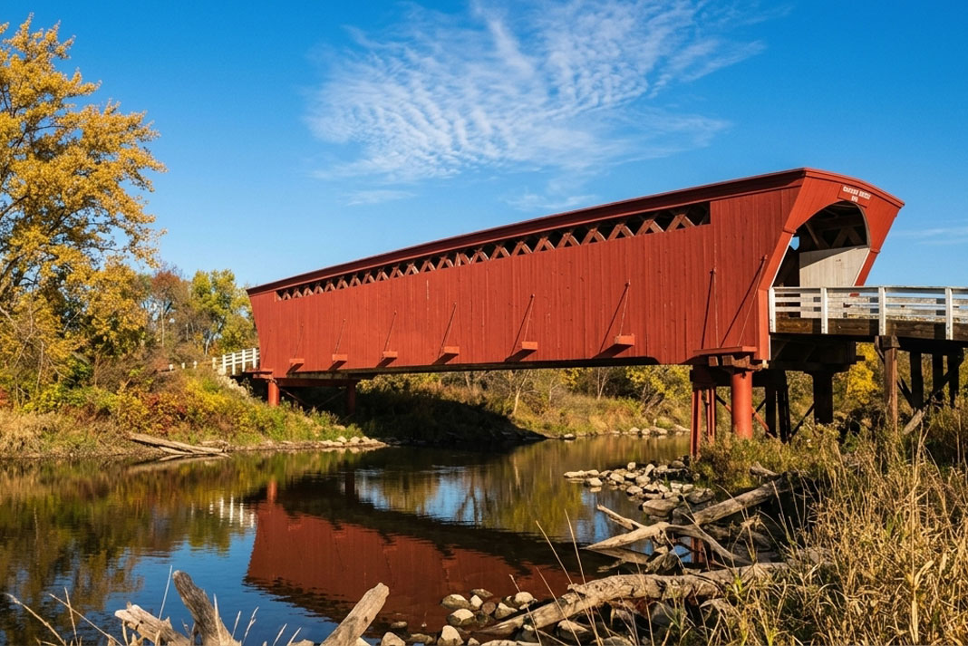

Start at the Holliwell Bridge, southeast of Winterset off County Road G50. It’s the longest of the six covered bridges left in Madison County, and standing underneath it, looking up at the crisscrossed lattice of oak timbers overhead, you get the clearest sense of how these things actually went together. This isn’t a bridge dressed up to look old. It’s a working truss with a roof and walls built around it, and once you know why, the whole county’s collection makes a lot more sense.
What the builders were solving
Madison County’s bridges date mostly to the 1870s and 1880s, when local carpenters needed to span the Middle River, the North River, and creeks like Clanton and Cedar without steel or poured concrete. Their answer was the Town lattice truss, a design patented decades earlier by a Connecticut architect named Ithiel Town, built almost entirely from diagonal wooden planks pinned together with wooden pegs called trunnels. No iron bolts holding the whole thing up. Just interlocking oak, doing the work through geometry rather than hardware.
The problem with an exposed wooden truss is weather. Rain gets into the joints, the wood swells and contracts, and the whole structure starts to sag and rot within a couple decades. So builders like Benton Jones, who put up several of the county’s bridges, sided and roofed the trusses in pine boards. The covering had nothing to do with keeping horses calm or travelers dry, despite what you’ll hear at the gift shop. It was there to keep the load-bearing timber dry enough to last a century instead of twenty years.
What to expect when you arrive
Each bridge sits on a quiet gravel or paved county road, usually with a small pull-off and maybe a historical marker. Roseman Bridge, the most photographed of the six thanks to a certain 1990s novel and film, has a parking area and a short walk down to the creek. Most of the bridges are closed to vehicle traffic now and open only to foot traffic, which is worth knowing before you plan a driving loop that assumes you’ll cross each one. Cedar Bridge, east of Winterset, has actually been rebuilt twice after arson fires, most recently reconstructed using the same joinery methods as the original. That’s not a small detail. It tells you these aren’t static museum pieces. They’re structures the county has chosen, repeatedly, to keep building the old way rather than replace with something modern and cheaper.
When to go, and why it matters
Fall is the obvious answer, and for good reason. The timber and the turning leaves along the riverbanks share the same palette, and the light through the truss gaps in late afternoon is worth the drive on its own. But October brings crowds, especially around the covered bridge festival weekend, and parking at Roseman can back up along the shoulder. Go on a weekday morning if you can. Spring works too, when the rivers are running higher and the bridges make more sense as flood-crossing infrastructure rather than scenery. Summer is fine but buggy near the creek banks. Winter access depends on county road maintenance, and a couple of the more remote bridges sit on roads that don’t get plowed with any urgency.
What else is nearby
Winterset itself is the obvious base, with the Madison County Courthouse anchoring the town square and enough small-town commerce around it to fill a lunch break between bridges. The county seat also has the birthplace site of John Wayne, if that’s your interest, a few blocks off the square. St. Charles and Peru are small enough that you’ll drive through them without noticing unless you’re watching the map, but they mark useful turns on the bridge loop. If you want the fuller history of how and why these structures were preserved, the State Historical Society of Iowa keeps records on the county’s restoration work, and Travel Iowa publishes current maps and seasonal event information for the bridge loop, which changes enough year to year that it’s worth checking before you go.
The thing most people get wrong
Visitors assume all nineteen of the original covered bridges are still out there somewhere, tucked down some gravel road GPS won’t find. They’re not. Fire, floods, and simple neglect took most of them well before anyone thought to protect the rest, and the six that remain survive because the county has actively maintained and in some cases rebuilt them, not because they were forgotten and left alone. Don’t go looking for a seventh. And don’t assume you can drive across the ones that are left. Check locally before you plan a route that has your car crossing Holliwell or Cedar, because both are pedestrian bridges now, and the disappointment of finding a barricade instead of a road is a very specific kind of Iowa afternoon.